Arup has used its heat-mapping tool, UHeat, to analyse heat risk throughout London’s built environment.
Arup was commissioned by the mayor of London to establish heat risk across the capital’s homes, neighbourhoods and essential properties in the wake of climate change. The analysis, revealed in the Properties Vulnerable to Heat Impacts in London report, comes after the recent warning that 2023 was the hottest year on Earth since records began.
UHeat uses a combination of satellite imagery and open-source climate data to analyse huge areas of cities, according to Arup. It can identify the particular buildings, structures and materials that are causing temperatures to rise.
“The materials we use to build, like concrete and metal, absorb heat in the day and emit it at night. Commonly referenced as the urban heat island (UHI) effect, factors including heat emitted from cars and air-conditioning units, exacerbate the impact and human experience of heat in cities,” Arup said.
In particular, Arup’s report focuses on the city’s “essential properties” such as schools, hospitals, care homes, residential buildings and neighbourhoods. It also highlights a direct correlation between a higher heat risk and areas that have greater socio-economic vulnerabilities.
Key findings
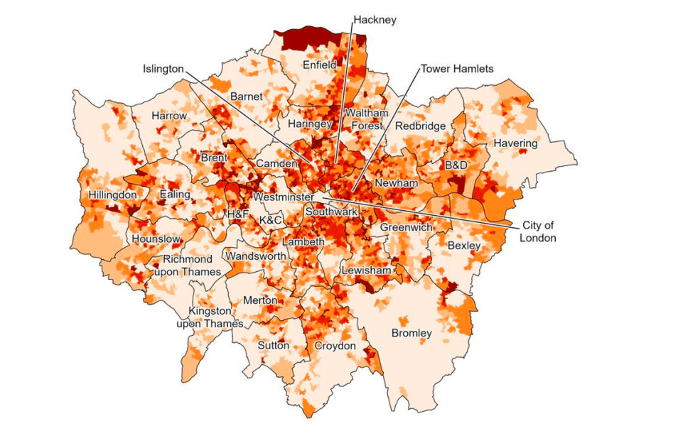
Arup found that schools in Islington, Hackney and Tower Hamlets show greater heat risk, while those towards the outskirts such as Hillingdon, Kingston upon Thames, Bromley and Barnet show the least heat risk.
There is a greater heat risk for hospitals in areas towards the centre of London. This includes central boroughs such as Southwark, Tower Hamlets, Hackney, Islington and Kensington & Chelsea. This is due to the UHI effect.
That effect also impacts care homes towards central London, which have a higher heat risk.
There is a higher heat risk for residential properties in neighbourhoods in central boroughs such as Hackney, Tower Hamlets, Islington and Camden. These boroughs tend to have a higher proportion of flats, which are considered to be more vulnerable to overheating, compared with outer London boroughs that have a higher proportion of houses. Areas towards the outskirts, such as Bromley, Havering and Hillingdon show the lowest heat risk to residential properties.
Bold choices now
Damien McCloud, project director, director, and data and geospatial specialist at Arup, said: “London is getting hotter, with the design of our urban capital contributing to how heat impacts different spaces. It is vital these findings inform GLA’s efforts and broader policymaking so that meaningful interventions can be put in place to protect Londoners in buildings most at risk of overheating. At the same time, London needs a holistic approach to reducing the impact of the different consequences of climate change.”
Shirley Rodrigues, deputy mayor of environment and energy, added: “The mayor commissioned this report to help us prioritise the areas and public services that most need adaptation in the face of extreme heat. It’s unacceptable that people living in London’s most deprived areas are the most vulnerable to overheating. If we make bold choices now, we can build a better, greener and safer London for all.”
This article first appeared on BIMplus